Mapping out the land in Zanzibar

Thanks to the data collection exploits of drone technology, the process of titling land on the Tanzanian archipelago of Zanzibar is progressing at a rate faster than would have been possible without the help of drones, according to an official involved in the process.
At the last count in 2012, Zanzibar has around 1,504million people crammed within the 2,462 square kilometres of land available, and authorities in the region have been struggling provide certificates of occupancy to Zanzibar’s growing population.
At least that was until a pilot project using drones and digital mapping was commissioned, and proved effective in offering a more efficient way to provide residents with land titles.
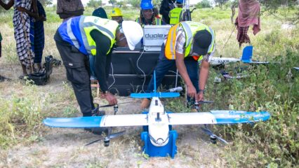
According to a report by Primož Kovačič, co-founder and managing director of Nairobi-based Geographic Information Systems (GIS) and technology consulting company, Spatial Collective, the collaborative efforts pitting his company; the Zanzibar Mapping Initiative and the Zanzibar’s Commission for Lands (COLA) helped map the archipelago using drones.
As a result, this made easier the digitisation process for all the 500,000 buildings identified; which gave the authorities a true picture of just how many building structures were up throughout the islands for the first time.
“Previous efforts to allocate property titles to owners of the roughly 500,000 structures identified in Zanzibar through drone mapping had failed, and the cost of employing an army of door-to-door surveyors with surveying equipment was too high, and would take too long,” explains Kovacic.
“Traditional data collection and management methods, mostly paper-based and expensive, have not kept up with the demand for property ownership. Local authorities had determined that there were not enough surveyors and equipment for doorstep data collection, and the eventual issuance of certificates could take years, if it happened at all. The records indicating how many properties there are on the islands did not exist.
“But a pilot project using drones and digital mapping is offering the archipelago a more efficient way to provide residents with land titles.
“Based on this groundwork, Spatial Collective and COLA obtained a grant from a Cities Alliance programme supporting land tenure in African cities, to modernise the land adjudication process and help citizens acquire title deeds. By pairing tablets with drone imagery, Spatial Collective collected data on 900 properties.”
Most buildings on the Zanzibari islands are an entangled mass of asphalt, bricks and tin packed back-to-back, and it has been really hard to tell where one property ends, and another begins. Up to now, the actual demarcation of residences has remained largely informal.
With the way people are crammed up in the small space offered by the islands in urban areas, it would have taken years to document every piece of the land, had new technologies not stepped in to help the situation; accelerating the documentation process, and enabling the deployment of large numbers of enumerators.
Kovacic explains; “To speed up data collection, Spatial Collective and COLA worked together to understand the process of adjudication, and suggest ways of removing bottlenecks. With the help of land tech platform Cadasta, Spatial Collective built a digital platform merging drone imagery with a redesigned adjudication form to collect data such as details on owners, boundary points, scans of relevant documents, and signatures.
“Community members were trained to collect data themselves, reducing the collection time. COLA then prepared the certificates of occupancy to be approved by the Ministry of Lands, Energy, and Water. The process of issuing the certificates to the owners was also reduced, and 80 residents have already having received their certificates.”
There have still been a few issues though, even with the drones involved; not least one of which has been the temporary shelving of the process due to the Covid-19 pandemic.
But, as Kovacic states, that was not even the most teething issue.
“One caveat is the accuracy of the data on the location of boundary points,” he says. “The application used by the project did not match the system used by the government.
“By incorporating 7cm high-resolution drone imagery into the workflow, the issue could be fixed, and the data achieved good-enough accuracy, satisfying adjudication officers and communities alike.
“For a time, COVID-19 temporarily interrupted the land titling process. Yet the local government chose to continue data collection despite the pandemic. COLA has since expressed interest in expanding the project while incorporating other digital strategies to help regularise land tenure for the entire island nation.”


0 Comments